Isaias becomes major hurricane as it barrels toward Florida Panhandle, NHC says
Published in News & Features
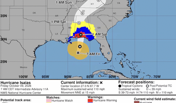
TAMPA, Fla. -- Hurricane Isaias, on a path to become the first Atlantic hurricane to strike the U.S. this year, muscled up to major hurricane strength Friday morning as it churned closer to the Florida Panhandle, according to the National Hurricane Center.
As of 8:20 a.m. Friday, Isaias was about 240 miles south of Pensacola and had sustained winds topping out at 120 mph, making it a Category 3 storm, forecasters said in an update.
Isaias (pronounced ees-ah-EE-ahs) is likely to remain a dangerous hurricane at landfall either Friday night or early Saturday, and forecasters warned that people living between Ocean Springs, Mississippi and the Bay and Gulf County line in Florida should rush to complete storm preparations as the hurricane moves north-northeast at about 15 mph.
On Thursday night, Florida Gov. Ron DeSantis expanded a state of emergency to include 27 counties as forecasters projected the storm could bring up to 9 feet of surge at the Alabama and Florida border.
Isaias was expected to take a northward turn later Friday and make its final approach toward the U.S. northern Gulf Coast in the afternoon, forecasters said.
Meteorologists have predicted for days that strong wind shear near the northern Gulf coast would help weaken the storm before landfall, but they noted Friday that time is of the essence:
“This is a tenuous spot because it would only take about a 6-(hour) delay in the onset of the shear to bring a stronger hurricane than expected onshore,” forecasters wrote in a 5 a.m. update.
Even though the storm is gearing up to make landfall hundreds of miles away from the Tampa Bay area, the region is still likely to feel the “peripheral impact” of Isaias Friday and into the weekend, according to Rick Davis, a meteorologist with the National Weather Service in Tampa.
What does that look like here? Expect choppier, wavier seas; low-lying streets that are prone to flooding could be flooded again and heavy rainfall can be expected through the weekend, Davis said.
The risk of rip currents along Pinellas beaches remains high into Sunday, Davis said, and conditions could be dangerous for anglers or boaters.
“If you’re a mariner, keep your boats in the port today as seas and swells begin to move ashore,” Davis said Friday morning.
A storm surge and higher-than-normal tides could be influenced by the strong pull of a new moon, with surge forecast between 1 to 3 feet in the Tampa Bay area, Davis said. That likely doesn’t mean flooding will enter into homes, he said, but it could mean water in low-lying streets.
As for rainfall, the region had seen up to 4 inches since Tuesday, with up to 3 more inches expected through the weekend, Davis said. Already over-saturated soil could see even more water, making flooding worse.
©2026 Tampa Bay Times. Visit at tampabay.com. Distributed by Tribune Content Agency, LLC.






Comments