Forecasters say Gulf system could become season's first hurricane
Published in News & Features
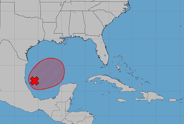
ORLANDO, Fla. — A system that has formed in the Gulf could become the season’s first Atlantic hurricane, some forecasters predict, potentially ending the longest stretch without any named storms since satellite tracking began 60 years ago.
The National Hurricane Center on Tuesday said there was a 100% chance the system will develop into the season’s ninth tropical depression or storm, and weather site AccuWeather predicts the system could grow into at Category 1 hurricane before landfall near the Mississippi-Alabama border on Saturday morning.
The NHC warned that regardless of development, heavy rainfall and associated flooding impacts could hit portions of the Gulf Coast, southeastern U.S. and Florida later this week and into the weekend.
“The storm is already becoming better organized faster than expected, and the environment around it is becoming increasingly favorable for strengthening,” said AccuWeather hurricane expert Nicholas Arman. “The warm waters in the Gulf will provide plenty of fuel, and winds high in the atmosphere are lining up in a way that could help the storm strengthen more efficiently.”
As of the NHC’s 2 p.m. tropical outlook, the broad area of low pressure, now dubbed Invest 92L, has more organized showers and thunderstorms in the southwestern Gulf, while surface pressures are falling gradually.
“Continued development of this system is expected, and a tropical depression is anticipated to form over the next day or so while it drifts eastward,” forecasters said Tuesday. “The low pressure area could bring gusty winds and areas of heavy rain to the western portions of the Yucatan Peninsula of Mexico in a couple of days.”
The system is forecast to turn to the north or northeast and head toward the northern Gulf Coast by the end of the week.
An NOAA Gulfstream jet was set to fly into the system Tuesday to sample its environment, while both Air Force and NOAA reconnaissance aircraft are scheduled to investigate the system Wednesday.
The NHC said it was too early to tell specific impacts to the northern Gulf Coast, but interests from the Florida Panhandle to Louisiana should monitor the system’s progress. The National Weather Service in Melbourne stated the latest guidance keeps the system west of Central Florida.
If it were to spin up into a named system, it could become Tropical Storm Isaias.
The hurricane season has seen the formation of tropical storms Arthur, Bertha, Cristobal, Dolly, Edouard, Fay, Gonzalo and Hanna.
For the first time in 60 years, however, none has developed into a hurricane in the Atlantic with less than two months left in the season.
Hurricane season began June 1 and runs through Nov. 30, but the height of hurricane season runs from mid-August through mid-October.
The reason for the lack of hurricanes has been an extremely strong El Niño weather pattern, which is warming surface temperatures in the Pacific Ocean. This generates wind shear preventing storms from strengthening in the Atlantic.
Sammy Hadi, a lead meteorologist with the National Weather Service in Miami, told the South Florida Sun Sentinel last week that the “top of these storms that are developing are being blown off.”
The National Oceanic and Atmospheric Administration in August had updated its seasonal forecast to expect between seven and 13 named storms this year. Of those, two to six would become hurricanes. It also predicted that there might not be any major hurricanes this year, or at most two.
Already, 2026 was forecast to have lower-than-average storm generation, and that has been reduced even further with the latest forecasts from the NOAA and other weather groups.
An average year would see 14 named storms and seven hurricanes, with three of those growing to Category 3 strength or higher.
------------
©2026 Orlando Sentinel. Visit at orlandosentinel.com. Distributed by Tribune Content Agency, LLC.






Comments