Hurricane center gives low chance for system to form in Gulf
Published in News & Features
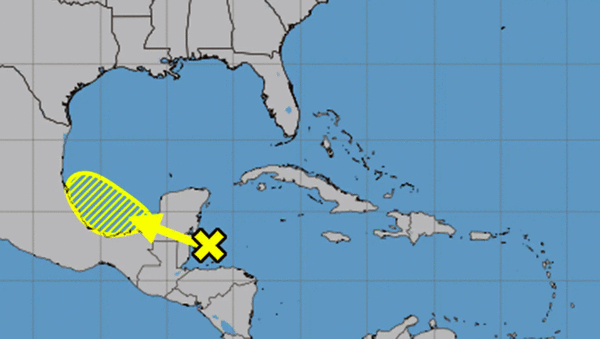
The National Hurricane Center began tracking a system in the Caribbean that could move into the Gulf waters off Mexico over the weekend with a chance to develop into the season’s next tropical depression or storm.
In its 8 a.m. Friday tropical outlook, the NHC stated the area of showers and thunderstorms was in the northwestern Caribbean Sea approaching Belize and Mexico’s Yucatán Peninsula, but expected to move west-northwest into the Bay of Campeche in the southwestern Gulf waters on Saturday or Sunday where a low pressure area could form.
“Subsequent slow development is possible on Sunday or Monday if the system remains offshore of the coast of Mexico,” forecasters said. “Regardless of development, locally heavy rains are possible over portions of Belize, Guatemala, and southeastern Mexico during the next few days.”
The NHC first began tracking the system Thursday night. It gave it a 10% chance to develop in the next two days and 20% in the next seven.
The 2025 Atlantic hurricane season that officially began on June 1 has been quiet so far with only one named storm — Tropical Storm Andrea — that formed for less than a day out in the middle of the Atlantic last week.
The next name on this season’s list is Barry.
It was the latest since 2014 that a named system had formed. That year the first named storm didn’t come until June 30.
Despite the late start, this year’s hurricane season is still predicted to be above-normal by the National Oceanic and Atmospheric Administration.
The agency predicts 13 to 19 named storms, of which 6-10 will become hurricanes. Three to five of those would grow into major hurricanes of Category 3 strength or higher.
Hurricane season runs through Nov. 30.
-------------
©2025 Orlando Sentinel. Visit at orlandosentinel.com. Distributed by Tribune Content Agency, LLC.


Comments